Colorado -- Brown's Canyon National Monument -- USFS/BLM Want YOUR Inputs...
2 posters
Page 1 of 1

Colorado -- Brown's Canyon National Monument -- USFS/BLM Want YOUR Inputs...
![]() by Admin Wed Dec 14, 2016 8:26 am
by Admin Wed Dec 14, 2016 8:26 am
Greetings Gold Adventurers...
With Obama cramming the Brown's Canyon National Monument (BCNM) down our collective throats, again by executive fiat, with his pen by EO in February of 2015, we sadly see 21,586 more acres of OUR public lands forever withdrawn from mineral entry, claiming, mining......when the history of this whole area is gold mining. And, to add insult to injury, the friggin' BLM secretly moved to withdraw an additional 230 acres of Arkansas River corridor below Obama's new NM for the eco-Nazis, towards Salida, without any public comment or hearings. Obama's already designated or expanded 23 NMs in his 8 sorry years.....forever withdrawing, ruining over 265 million acres of public lands for the majority of land users and prospectors.....and locking them all up for the near exclusive use of one user group -- extreme environmentalists -- that I call eco-Nazis.
So, here for almost 2 years, the USFS/BLM have been drafting their first EA/Mgt Plan" for the actual running of the BCNM in secret, behind closed doors. Now, they say they're looking for public comments on what WE, the land owning public, want them to "deliver" to us via the new BCNM.
Therefore, I highly encourage everyone to give them inputs, pile on as to keeping BCNM open and allowing unfettered access, use and enjoyment......from guaranteeing water rights, grazing rights, to keeping the historic Turret Trail (and others) and forest roads & county roads and disbursed camp sites open ......to keeping access to Aspen Ridge open to 4-WDers and ATVers to view the fall colors, to demanding we get to "recreationally" gold prospect/pan/sluice in the Arkansas river up to the normal high water line....and metal detect the hills too.
Some of the best flood gold in the Arkansas River is between Cache Creek (at Granite) and Salida. Below Salida, the gold drops off, gets finer and finer... Not right they try and deny us prospectors 7 miles of premium river corridor, plus the 230 acres of river corridor the BLM secretly withdrew below the BNCN towards Salida as well.
Also, all rock hounds, gem collectors should speak up too about full access to the BCNM to still hike, collect gems, volcanic rocks, Apache tears, garnets, whatever too.....especially around the famous Ruby Mountain area of the now BCNM.
FWIW, as to "Special Places" they want to hear about, I will be highlighting as a minimum:
1). The Arkansas River for recreational gold prospecting using non-motorized equipment up to the high water flood mark
2). The Turret Trail for its Wild West mining history/lore
3). Ruby Mountain area for its volcanic rocks, garnets, topaz, rock hounding aspects, etc.
4). Aspen Ridge for off road/disbursed camping/ATVing, 4-WDing enjoyment/fall colors
FYI, the historic gold mining town/area of Turret is just to the South of the BCNM boundary with the famous Gold Bug and Golden Wonder Mines. http://digital.denverlibrary.org/cdm/ref/collection/p15330coll22/id/38760 http://westernmininghistory.com/mine_detail/10013830
https://www.coloradohistoricnewspapers.org/cgi-bin/colorado?a=d&d=SDM19090928-01.2.6 http://westernmininghistory.com/mine_detail/10013831 Lots of other smaller, now unnamed gold mines in those hills too...
The reason white men came, settled Chaffee County back in the day was mining..........not rafting, kayaking & fishing. BLM & USFS need to hear that, know that, not ignore that fact....and keep the BCNM open to ALL the uses Udall/Bennet/Hickenlooper and BCNM supporters promised us!
Go to the URL in the e-mails below, offer the USFS/BLM your public comments, while you still can have a say!!!
Thanks in advance for your support!
Randy Witham "C-17A"
Public Land Owner/Gold Prospector
Buena Vista, CO 81211
------------------
From: Bayless - DNR, Rose [mailto.bayless@state.co.us]
Sent: Tuesday, December 13, 2016 11:11 AM
To: Bob Hamel; Christina King; Dan Prenzlow; Dave Potts; Ed Perko; Fred Rasmussen; Hayden Mellsop; James Broderick; Jim Aragon; Jim Pitts; Joe Greiner; John Kreski; John Nahomenuk; Justin Zeisler; Keith Berger; Leslie Tyson; Mark Robbins; Marshall Butler; Mary Moore; Melissa Garcia; Mike Bordogna; Rob Ferris; Robert White; Rose Bayless; Skip Lee; Susan Tweit; Wendy Rombold
Subject: Fwd: PLEASE POST & DISTRIBUTE - BCNM online mapping
Please refer to the attached e-mail from Karla Rogers regarding Browns Canyon.
She is looking for information from people who have ties to Browns Canyon and what those ties may be.
Be sure and share this with your constituents.
Thank you!
Rose Bayless
Program Assistant
Arkansas Headwaters Recreation Area
P 719.539.7289 Ext 4702 | F 719.539.3771
307 West Sackett Ave, Salida, CO 81201
rose.bayless@state.co.us | www.cpw.state.co.us
"The care of rivers is not a question of rivers, but of the human heart" - Tanaka Shozo
---------- Forwarded message ----------
From: Rogers, Karla <knrogers@blm.gov>
Date: Thu, Dec 8, 2016 at 2:52 PM
Subject: Re: PLEASE POST & DISTRIBUTE - BCNM online mapping
To: Gina Bartlett <gina@cbuilding.org>, John Harner <jharner@uccs.edu>, "Dow, John R -FS" <jrdow@fs.fed.us>, "Lara, Ben -FS" <blara@fs.fed.us>, Kevin Knapp <kknapp@tierraplan.com>, "Cerveny, Lee -FS" <lcerveny@fs.fed.us>, "Skinner, Linda" <lskinner@blm.gov>, "Joe Vieira (Joseph_Vieira@blm.gov)" <Joseph_Vieira@blm.gov>, "White - DNR, Rob" <rob.white@state.co.us>, "Timock, Barbara -FS" <btimock@fs.fed.us>, Kyle Davidson - DNR <kyle.davidson@state.co.us>
I am re-sending my earlier email with only the jpg (not the PDF). The previous email seemed to fail to go to anyone outside of the BLM. My guess is the size of the PDF attachment. Here we go! My fingers are crossed it works.
Karla
On Thu, Dec 8, 2016 at 2:13 PM, Rogers, Karla <knrogers@blm.gov> wrote:
Please post and distribute
the attached flier
through your channels.
We will continue to post information about the online mapping tool as long as it is active (until mid January). If it is easier I've included
the
message
text
below
so you can copy and past
e to an email or website w/ a link to the URL as another option to using the
PDF or jpg. Expect another "refresher" in about two weeks.
Thanks!
Karla
--------------------------MESSAGE FOLLOWS------------------------------
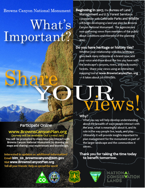
Do you have heritage or history ties with the Browns Canyon National Monument landscape? Whether your relationship with this landscape goes back many millennia or is brand new, now is an opportunity to add your voice and contribute your thoughts and ideas about the ties you have with the landscape’s canyons, rivers, and backcountry forests.
Follow the online link to an interactive mapping tool—it takes about 20 minutes.
Why are you being asked to share?
Beginning in 2017, the Bureau of Land Management and U.S. Forest Service in cooperation with Colorado Parks and Wildlife will begin developing a land use plan for Browns Canyon National Monument. By participating you will help increase understanding about the breadth of ways people interact with the area, what is meaningful about it, and its role in the way people live, work, and play. What you say will help develop an understanding of the monument as part of the larger landscape and communities it serves. This will be an opportunity to share what you think is important, valued, of meaning, or an emerging concern.
What is important to you about Browns Canyon National Monument? Please contribute your thoughts and ideas online through an interactive mapping tool.
----------------message ends--------------------------
Thank you!!
Karla
--
Karla Rogers
Landscape Architect/Social Scientist
Visual Resource Management - Human Dimensions of Landscape Approach - CADR
Bureau of Land Management, National Operations Center Branch of Technical Operations, OC-520
P.O. Box 25047, Denver, CO 80225-0047 (Building 50, Denver Federal Center)
303-236-6354 | knrogers@blm.gov
Our society will be defined not only by what we create but by what we refuse to destroy.
-John Sawhill
With Obama cramming the Brown's Canyon National Monument (BCNM) down our collective throats, again by executive fiat, with his pen by EO in February of 2015, we sadly see 21,586 more acres of OUR public lands forever withdrawn from mineral entry, claiming, mining......when the history of this whole area is gold mining. And, to add insult to injury, the friggin' BLM secretly moved to withdraw an additional 230 acres of Arkansas River corridor below Obama's new NM for the eco-Nazis, towards Salida, without any public comment or hearings. Obama's already designated or expanded 23 NMs in his 8 sorry years.....forever withdrawing, ruining over 265 million acres of public lands for the majority of land users and prospectors.....and locking them all up for the near exclusive use of one user group -- extreme environmentalists -- that I call eco-Nazis.
So, here for almost 2 years, the USFS/BLM have been drafting their first EA/Mgt Plan" for the actual running of the BCNM in secret, behind closed doors. Now, they say they're looking for public comments on what WE, the land owning public, want them to "deliver" to us via the new BCNM.
Therefore, I highly encourage everyone to give them inputs, pile on as to keeping BCNM open and allowing unfettered access, use and enjoyment......from guaranteeing water rights, grazing rights, to keeping the historic Turret Trail (and others) and forest roads & county roads and disbursed camp sites open ......to keeping access to Aspen Ridge open to 4-WDers and ATVers to view the fall colors, to demanding we get to "recreationally" gold prospect/pan/sluice in the Arkansas river up to the normal high water line....and metal detect the hills too.
Some of the best flood gold in the Arkansas River is between Cache Creek (at Granite) and Salida. Below Salida, the gold drops off, gets finer and finer... Not right they try and deny us prospectors 7 miles of premium river corridor, plus the 230 acres of river corridor the BLM secretly withdrew below the BNCN towards Salida as well.
Also, all rock hounds, gem collectors should speak up too about full access to the BCNM to still hike, collect gems, volcanic rocks, Apache tears, garnets, whatever too.....especially around the famous Ruby Mountain area of the now BCNM.
FWIW, as to "Special Places" they want to hear about, I will be highlighting as a minimum:
1). The Arkansas River for recreational gold prospecting using non-motorized equipment up to the high water flood mark
2). The Turret Trail for its Wild West mining history/lore
3). Ruby Mountain area for its volcanic rocks, garnets, topaz, rock hounding aspects, etc.
4). Aspen Ridge for off road/disbursed camping/ATVing, 4-WDing enjoyment/fall colors
FYI, the historic gold mining town/area of Turret is just to the South of the BCNM boundary with the famous Gold Bug and Golden Wonder Mines. http://digital.denverlibrary.org/cdm/ref/collection/p15330coll22/id/38760 http://westernmininghistory.com/mine_detail/10013830
https://www.coloradohistoricnewspapers.org/cgi-bin/colorado?a=d&d=SDM19090928-01.2.6 http://westernmininghistory.com/mine_detail/10013831 Lots of other smaller, now unnamed gold mines in those hills too...
The reason white men came, settled Chaffee County back in the day was mining..........not rafting, kayaking & fishing. BLM & USFS need to hear that, know that, not ignore that fact....and keep the BCNM open to ALL the uses Udall/Bennet/Hickenlooper and BCNM supporters promised us!
Go to the URL in the e-mails below, offer the USFS/BLM your public comments, while you still can have a say!!!
Thanks in advance for your support!
Randy Witham "C-17A"
Public Land Owner/Gold Prospector
Buena Vista, CO 81211
------------------

From: Bayless - DNR, Rose [mailto.bayless@state.co.us]
Sent: Tuesday, December 13, 2016 11:11 AM
To: Bob Hamel; Christina King; Dan Prenzlow; Dave Potts; Ed Perko; Fred Rasmussen; Hayden Mellsop; James Broderick; Jim Aragon; Jim Pitts; Joe Greiner; John Kreski; John Nahomenuk; Justin Zeisler; Keith Berger; Leslie Tyson; Mark Robbins; Marshall Butler; Mary Moore; Melissa Garcia; Mike Bordogna; Rob Ferris; Robert White; Rose Bayless; Skip Lee; Susan Tweit; Wendy Rombold
Subject: Fwd: PLEASE POST & DISTRIBUTE - BCNM online mapping
Please refer to the attached e-mail from Karla Rogers regarding Browns Canyon.
She is looking for information from people who have ties to Browns Canyon and what those ties may be.
Be sure and share this with your constituents.
Thank you!
Rose Bayless
Program Assistant
Arkansas Headwaters Recreation Area
P 719.539.7289 Ext 4702 | F 719.539.3771
307 West Sackett Ave, Salida, CO 81201
rose.bayless@state.co.us | www.cpw.state.co.us
"The care of rivers is not a question of rivers, but of the human heart" - Tanaka Shozo
---------- Forwarded message ----------
From: Rogers, Karla <knrogers@blm.gov>
Date: Thu, Dec 8, 2016 at 2:52 PM
Subject: Re: PLEASE POST & DISTRIBUTE - BCNM online mapping
To: Gina Bartlett <gina@cbuilding.org>, John Harner <jharner@uccs.edu>, "Dow, John R -FS" <jrdow@fs.fed.us>, "Lara, Ben -FS" <blara@fs.fed.us>, Kevin Knapp <kknapp@tierraplan.com>, "Cerveny, Lee -FS" <lcerveny@fs.fed.us>, "Skinner, Linda" <lskinner@blm.gov>, "Joe Vieira (Joseph_Vieira@blm.gov)" <Joseph_Vieira@blm.gov>, "White - DNR, Rob" <rob.white@state.co.us>, "Timock, Barbara -FS" <btimock@fs.fed.us>, Kyle Davidson - DNR <kyle.davidson@state.co.us>
I am re-sending my earlier email with only the jpg (not the PDF). The previous email seemed to fail to go to anyone outside of the BLM. My guess is the size of the PDF attachment. Here we go! My fingers are crossed it works.
Karla
On Thu, Dec 8, 2016 at 2:13 PM, Rogers, Karla <knrogers@blm.gov> wrote:
Please post and distribute
the attached flier
through your channels.
We will continue to post information about the online mapping tool as long as it is active (until mid January). If it is easier I've included
the
message
text
below
so you can copy and past
e to an email or website w/ a link to the URL as another option to using the
PDF or jpg. Expect another "refresher" in about two weeks.
Thanks!
Karla
--------------------------MESSAGE FOLLOWS------------------------------
Do you have heritage or history ties with the Browns Canyon National Monument landscape? Whether your relationship with this landscape goes back many millennia or is brand new, now is an opportunity to add your voice and contribute your thoughts and ideas about the ties you have with the landscape’s canyons, rivers, and backcountry forests.
Follow the online link to an interactive mapping tool—it takes about 20 minutes.
Why are you being asked to share?
Beginning in 2017, the Bureau of Land Management and U.S. Forest Service in cooperation with Colorado Parks and Wildlife will begin developing a land use plan for Browns Canyon National Monument. By participating you will help increase understanding about the breadth of ways people interact with the area, what is meaningful about it, and its role in the way people live, work, and play. What you say will help develop an understanding of the monument as part of the larger landscape and communities it serves. This will be an opportunity to share what you think is important, valued, of meaning, or an emerging concern.
What is important to you about Browns Canyon National Monument? Please contribute your thoughts and ideas online through an interactive mapping tool.
----------------message ends--------------------------
Thank you!!
Karla
--
Karla Rogers
Landscape Architect/Social Scientist
Visual Resource Management - Human Dimensions of Landscape Approach - CADR
Bureau of Land Management, National Operations Center Branch of Technical Operations, OC-520
P.O. Box 25047, Denver, CO 80225-0047 (Building 50, Denver Federal Center)
303-236-6354 | knrogers@blm.gov
Our society will be defined not only by what we create but by what we refuse to destroy.
-John Sawhill

Admin- Admin
- Posts : 647
Join date : 2015-11-29
Age : 64
Location : Buena Vista, Colorado -

Re: Colorado -- Brown's Canyon National Monument -- USFS/BLM Want YOUR Inputs...
![]() by russau Wed Dec 14, 2016 1:47 pm
by russau Wed Dec 14, 2016 1:47 pm
And so go our "rights" could have figured as much coming from some damocrats! As they go out , they grab as much as they want!! I hope Trump uses his executive order to dump the damocrats BS !
russau- Posts : 486
Join date : 2015-11-30
Age : 77
Location : St. Louis , Misery
» Colorado -- More Snow!
» New BLM, EPA & USFS Warning Signs....
» USFS Continues to Close Roads, Camp Sites, Limit Public Access, Use and Enjoyment
» Colorado - Dredging the Arkansas River, Colorado -- 2 thru 6 May 2017
» Randy's Latest Keene Dredge Sluice Mods with Gold Hog Matting -- 6 Jul 16
» New BLM, EPA & USFS Warning Signs....
» USFS Continues to Close Roads, Camp Sites, Limit Public Access, Use and Enjoyment
» Colorado - Dredging the Arkansas River, Colorado -- 2 thru 6 May 2017
» Randy's Latest Keene Dredge Sluice Mods with Gold Hog Matting -- 6 Jul 16
Page 1 of 1
Permissions in this forum:
You cannot reply to topics in this forum